
Fichier:Map of Kiribati CIA WFB.png
Et gëtt keng méi héich Opléisung.
Map_of_Kiribati_CIA_WFB.png (325 × 350 Pixel, Fichiersgréisst: 9 KB, MIME-Typ: image/png)

|
Dieses Bild des Typs Map sollte als Vektorgrafik im SVG-Format neu erstellt werden. Vektorformate haben zahlreiche Vorteile; weitere Information unter Commons:Media for cleanup. Wenn dir eine SVG-Version dieses Bildes vorliegt, so lade diese bitte hoch. Nach dem Hochladen der Datei ist diese Vorlage auf der aktuellen Bildbeschreibungsseite durch die Vorlage {{Vector version available}}, oder kürzer {{Vva}}, zu ersetzen. Es ist empfohlen die neue SVG-Datei „Map of Kiribati CIA WFB.svg“ zu nennen – dann benötigt die Vorlage vector version available (bzw. vva) keinen Parameter.
|
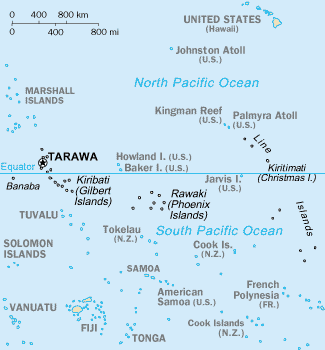
Resumé
CIA-WF map of Kiribati
Lizenz
Dieses Werk ist gemeinfrei, weil es Bildmaterial aus dem CIA World Factbook darstellt, das ursprünglich vom Zentralen Nachrichtendienst der Vereinigten Staaten veröffentlicht wurde.
|
 |
Versiounen
Klickt op e bestëmmten Zäitpunkt fir déi respektiv Versioun vum Fichier ze kucken.
| Versioun vum | Miniaturbild | Dimensiounen | Benotzer | Bemierkung | |
|---|---|---|---|---|---|
| aktuell | 15:35, 17. Sep. 2010 | | 325 × 350 (9 KB) | Ras67 | cropped |
| 09:15, 27. Mäe. 2005 |  | 330 × 354 (10 KB) | Wolfman~commonswiki | {{CIA-map}} |
Benotze vu Fichieren
Dës Säit benotzt dëse Fichier:
Globaalt Benotze vum Fichier
Dës aner Wikie benotzen dëse Fichier:
- Benotzt op af.wikipedia.org
- Benotzt op avk.wikipedia.org
- Benotzt op azb.wikipedia.org
- Benotzt op ban.wikipedia.org
- Benotzt op bjn.wikipedia.org
- Benotzt op br.wikipedia.org
- Benotzt op bs.wikipedia.org
- Benotzt op ceb.wikipedia.org
- Benotzt op cs.wikipedia.org
- Benotzt op da.wikipedia.org
- Benotzt op de.wikivoyage.org
- Benotzt op en.wikipedia.org
- Howland Island
- Jarvis Island
- Line Islands
- Tabuaeran
- List of towns and villages in Kiribati
- Lists of hospitals in Oceania
- Talk:List of sovereign states and dependent territories in Oceania
- List of airports in Kiribati
- Wikipedia:Featured picture candidates/February-2007
- Wikipedia:Featured picture candidates/Kingman Reef
- Outline of Kiribati
- Wikipedia:Graphics Lab/Image workshop/Archive/Nov 2008
- Ministry of Line and Phoenix Islands Development
- Benotzt op en.wikisource.org
- Benotzt op en.wikiversity.org
- Benotzt op eo.wikipedia.org
- Benotzt op es.wikipedia.org
- Benotzt op et.wikipedia.org
- Benotzt op eu.wikipedia.org
- Benotzt op fa.wikipedia.org
- Benotzt op fi.wikipedia.org
Kuckt globale Gebrauch vun dësem Fichier.