
Fichier:Klimagürtel-der-erde-polargebiete.png

Gréisst vun dëser Duerstellung: 800 × 400 Pixel. Aner Opléisungen: 320 × 160 Pixel | 640 × 320 Pixel | 1.024 × 512 Pixel | 1.280 × 640 Pixel | 3.600 × 1.800 Pixel.
Original Fichier (3.600 × 1.800 Pixel, Fichiersgréisst: 674 KB, MIME-Typ: image/png)
Resumé
| Beschreiwung |
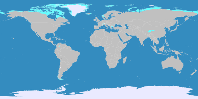
English: This map shows the Earth zones with a polar climate.
Ice cap climate
Tundra climate
Deutsch: Diese Karte stellt die polare Eisklimazone der Erde dar.
Eisklima
Tundrenklima |
| Datum | |
| Quell |
English: Own work on the basis of the following data: Deutsch: Selbst erstellt auf Basis dieser Geodaten:
|
| Auteur | LordToran |
| Autorisatioun (Dëse Fichier nach eng Kéier benotzen) |
|
| Aner Versiounen |
 |
Lizenz
Dëse Fichier ass ënner der Creative Commons Attribution-Share Alike 3.0 Unported Lizenz disponibel.
- Dir kënnt:
- D'Wierk deelen – kopéieren, verdeelen a weiderginn
- D'Wierk kombinéieren – adaptéieren
- Ënner dëse Konditiounen:
- Attributioun – Dir musst appropriéiert Informatiounen iwwer den Auteur uginn, e Link op d'Lizenz maachen, an uginn ob Ännerunge gemaach goufen. Dës Informatioune kënnen op eng räsonabel Manéier gi ginn, awer ouni datt den Androck entsteet datt deen deen d'Lizenz ginn huet Iech oder Är Benotzung approuvéiert oder ënnerstëtzt.
- ënner deselwechte Bedingunge weiderginn – Wann Dir dëst Wierk ännert, transforméiert oder dorop opbaut, dierft Dir dat Wierk, dat doraus entsteet, nëmmen ënner der selwechter oder enger kompatibeler Lizenz, verbreeden.
Versiounen
Klickt op e bestëmmten Zäitpunkt fir déi respektiv Versioun vum Fichier ze kucken.
| Versioun vum | Miniaturbild | Dimensiounen | Benotzer | Bemierkung | |
|---|---|---|---|---|---|
| aktuell | 21:07, 11. Okt. 2016 | | 3.600 × 1.800 (674 KB) | Maphobbyist | The Caspian Sea was omitted. The Köppen system is based on the concept that climate types are correlated with the natural vegetation. |
| 15:17, 15. Okt. 2007 |  | 3.600 × 1.800 (569 KB) | Lortordermur | ||
| 20:46, 5. Jun. 2007 |  | 3.445 × 1.731 (617 KB) | Lortordermur | == Beschreibung == {{Information |Description=Diese Karte stellt die polare Klimazone der Erde dar. {{legend|#eaeaff|Eisklima}} {{legend|#19ebed|Tundrenklima}} |Source=Selbst erstellt auf Basis [http://www.copernicus.org/EGU/hess/hessd/4/439/hessd-4-439 |
Benotze vu Fichieren
Dës Säit benotzt dëse Fichier:
Globaalt Benotze vum Fichier
Dës aner Wikie benotzen dëse Fichier:
- Benotzt op bg.wikipedia.org
- Benotzt op fy.wikipedia.org
- Benotzt op he.wikipedia.org
- Benotzt op hr.wikipedia.org
- Benotzt op hy.wikipedia.org
- Benotzt op ru.wikipedia.org