
Fichier:PIA16150 fig1-Mars Curiosity Rover-Glenelg Terrain.jpg

Original Fichier (1.280 × 781 Pixel, Fichiersgréisst: 704 KB, MIME-Typ: image/jpeg)
Resumé
| Beschreiwung |
English: 09.19.2012
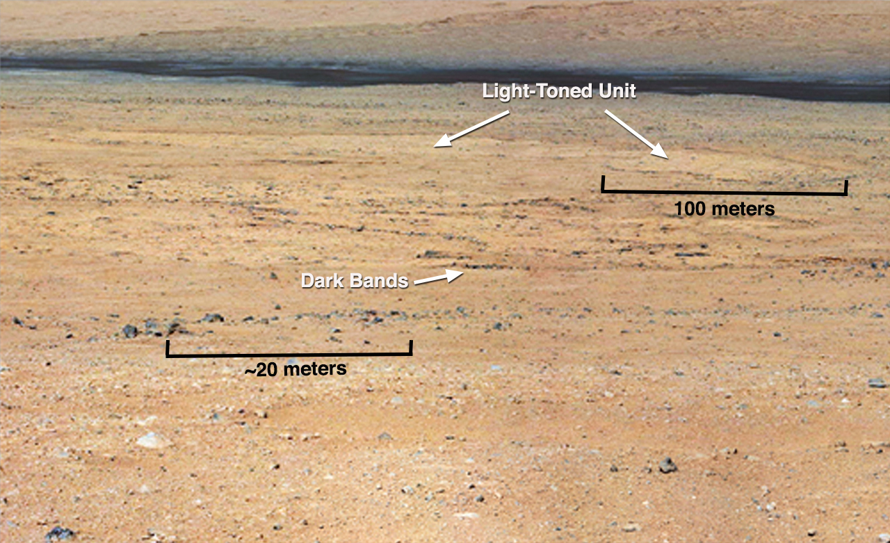
Dark Bands Run Through Light Layers (Annotated) This mosaic from the Mast Camera on NASA's Curiosity rover shows a close-up view looking toward the "Glenelg" area, where three different terrain types come together. All three types are observed from orbit with the High-Resolution Imaging Science Experiment (HiRISE) camera on NASA's Mars Reconnaissance Orbiter. By driving there, Curiosity will be able to explore them. One of these terrain types is light-toned with well-developed layering, which likely records the deposition of sedimentary materials. There are also black bands that run through the area and might constitute additional layers that alternate with the light-toned layer(s). The black bands are not easily seen from orbit and are on the order of about 3.3-feet (1-meter) thick. Both of these layer types are important science targets. This mosaic is composed of images taken with the Mastcam 100-millimeter camera.Polski: Ciemne pasma przebiegające wzdłuż jasnych warstw Ta mozaika zdjęć wykonanych przez jedną z kamer masztowych należącego do NASA łazika Curiosity pokazuje zbliżenie terenu, patrząc w stronę obszaru "Glenelg", w którym spotykają się trzy różne typy terenu. Wszystkie trzy typy terenu są obserwowane z orbity przez teleskop HiRISE zamontowany na orbiterze Mars Reconnaissance Orbiter. Kiedy Curiosity dojedzie do obszaru Glenelg będzie prowadzić eksploracje tego obszaru. Jednym z trzech typów jest teren jasno stonowany, z dobrze rozwiniętą strukturą warstw, który prawdopodobnie zawiera nagromadzone materiały osadowe. Istnieją także ciemne pasy, przebiegające przez obszar Glenelg i mogą stanowić dodatkowe warstwy, przeplatane z warstwami jasnymi. Ciemne pasy nie są łatwo widoczne z orbity i są rzędu około 1 metra grubości. Oba typy tych warstw są związane z ważnymi oczekiwaniami naukowców względem badań planowanych na tym obszarze. Mozaika ta, składa się ze zdjęć wykonanych przez jedną z dwu kamer masztowych ang. MastCam, kamerą 100-milimetrową. Zdjęcie posiada polskie adnotacje. Kliknij aby je uruchomić Image Credit: NASA/JPL-Caltech/MSSS |
| Datum | |
| Quell | http://photojournal.jpl.nasa.gov/figures/PIA16150_fig1.jpg |
| Auteur | NASA/JPL-Caltech/MSSS |
| Aner Versiounen | http://photojournal.jpl.nasa.gov/catalog/PIA16150 |
Lizenz
| Diese Datei ist gemeinfrei (public domain), da sie von der NASA erstellt worden ist. Die NASA-Urheberrechtsrichtlinie besagt, dass „NASA-Material nicht durch Urheberrecht geschützt ist, wenn es nicht anders angegeben ist“. (NASA-Urheberrechtsrichtlinie-Seite oder JPL Image Use Policy). | ||
 |
Warnung:
|
| Annotations | This image is annotated: View the annotations at Commons |
Versiounen
Klickt op e bestëmmten Zäitpunkt fir déi respektiv Versioun vum Fichier ze kucken.
| Versioun vum | Miniaturbild | Dimensiounen | Benotzer | Bemierkung | |
|---|---|---|---|---|---|
| aktuell | 11:51, 20. Sep. 2012 | | 1.280 × 781 (704 KB) | Drbogdan | User created page with UploadWizard |
Benotze vu Fichieren
Dës Säit benotzt dëse Fichier:
Globaalt Benotze vum Fichier
Dës aner Wikie benotzen dëse Fichier:
- Benotzt op en.wikipedia.org
- Benotzt op es.wikipedia.org
- Benotzt op pl.wikipedia.org
- Benotzt op ru.wikipedia.org
- Benotzt op vi.wikipedia.org
- Benotzt op zh.wikipedia.org