
Fichier:Satellite image of France in August 2002.jpg

Gréisst vun dëser Duerstellung: 780 × 600 Pixel. Aner Opléisungen: 312 × 240 Pixel | 624 × 480 Pixel | 999 × 768 Pixel | 1.280 × 985 Pixel | 2.560 × 1.969 Pixel | 5.200 × 4.000 Pixel.
Original Fichier (5.200 × 4.000 Pixel, Fichiersgréisst: 3,75 MB, MIME-Typ: image/jpeg)
| Beschreiwung |
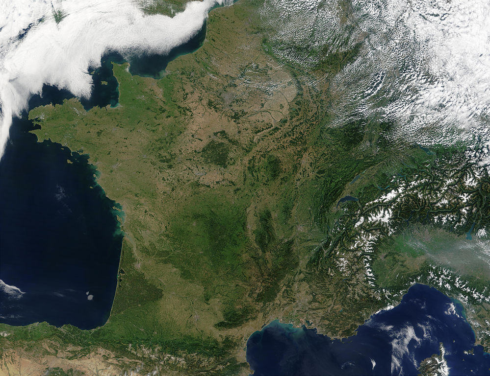
English: Satellite image of France acquired August 14, 2002, by the Terra satellite.
Suomi: Satelliittikuva Ranskasta elokuussa 2002 |
| Datum | |
| Quell |
Slightly cropped image. Original taken from NASA's Visible Earth: [1]. Credit: Jacques Descloitres, MODIS Rapid Response Team, NASA/GSFC |
| Auteur | Jacques Descloitres, MODIS Rapid Response Team, NASA/GSFC |
| Diese Datei ist gemeinfrei (public domain), da sie von der NASA erstellt worden ist. Die NASA-Urheberrechtsrichtlinie besagt, dass „NASA-Material nicht durch Urheberrecht geschützt ist, wenn es nicht anders angegeben ist“. (NASA-Urheberrechtsrichtlinie-Seite oder JPL Image Use Policy). | ||
 |
Warnung:
|
Dieses Bild war am 4. Mai 2005 das Bild des Tages. Es hatte die folgende Beschreibung: Deutsch: Frankreich aus dem Weltraum gesehen Andere Sprachen:
Ænglisc: Francland gesewen of woruldrúme Bân-lâm-gú: Tùi thài-khong khoàⁿ Hoat-kok. Català: França des de l'espai. Čeština: Francie při pohledu z vesmíru Cymraeg: Frainc o'r gofod. Deutsch: Frankreich aus dem Weltraum gesehen English: France from space Français : La France vue de l'espace. Galego: Francia Italiano: La Francia vista dal satellite. Nederlands: Frankrijk vanuit de ruimte. Norsk bokmål: Frankrike fra rommet Polski: Francja z kosmosu Slovenčina: Francúzsko pri pohľade z vesmíru Suomi: Elokuinen manner-Ranska satelliittikuvassa Svenska: Satellitbild på Frankrike Беларуская: Францыя з космасу Български: Франция от космоса Русский: Франция из космоса ไทย: ประเทศฝรั่งเศสเมื่อมองจากอวกาศ 한국어: 우주에서 바라본 프랑스 日本語: 宇宙から見たフランス 中文: 法国卫星照片 |
Versiounen
Klickt op e bestëmmten Zäitpunkt fir déi respektiv Versioun vum Fichier ze kucken.
| Versioun vum | Miniaturbild | Dimensiounen | Benotzer | Bemierkung | |
|---|---|---|---|---|---|
| aktuell | 10:50, 15. Jan. 2008 | | 5.200 × 4.000 (3,75 MB) | Kyle the hacker | uncropped, better definited version |
| 12:30, 8. Mäe. 2005 |  | 3.930 × 3.965 (2,82 MB) | Hautala | {{PD-USGov-NASA}} Satellite image of France in August 2002. Slightly cropped image. Original taken from NASA's Visible Earth, http://visibleearth.nasa.gov/view_rec.php?id=4202 . |
Benotze vu Fichieren
Dës Säit benotzt dëse Fichier:
Globaalt Benotze vum Fichier
Dës aner Wikie benotzen dëse Fichier:
- Benotzt op af.wikipedia.org
- Benotzt op an.wikipedia.org
- Benotzt op ar.wikipedia.org
- بولا جاك
- جاك كفالييه
- شارل ديدييه
- نيكيز أوغست ديفو
- جون باتيست تشارلز لوكاس
- لوي لو برانس
- دانييل أوبيه
- جويمي دوفاي
- أوجين سكرايب
- آلان بوهر
- سوفانوفونج
- أندريه جيلفي
- ميشيل دوك جونناز
- موريل كاسالز
- فيوليت فيردي
- ماريون تورنو-برانلي
- الكسندر استروك
- لويس جوردان
- باتاشو
- آلان رينيه
- كريستوف دو مارجري
- برناديت لافون
- كلود ميلر
- كلود ليلوش
- كارول بوكيه
- فاني اردانت
- انوك ايمي
- بياتريس دالي
- جان جيرو
- تشارلز بيرلنج
- أرنولد فان شينب
- الين بومبارد
- جان فرانسوا دينيو
- جان بول روسيون
- دينيس بوداليدس
- باتريس شيرو
- فرانسوا دو لاروشفوكو
- بيرتراند كونت تولوز
- شارل ستوبين
- غاستون كاستل
- إدموند دولاك
- أوغستين فيليكس فورتين
- جان باتيست هنري
- جان جيلبرت
- جان فنتوريني
- لوران دو لا هير
Kuckt globale Gebrauch vun dësem Fichier.