
Fichier:Vesta-Elevation.jpg
Et gëtt keng méi héich Opléisung.
Vesta-Elevation.jpg (500 × 500 Pixel, Fichiersgréisst: 43 KB, MIME-Typ: image/jpeg)
| Beschreiwung |
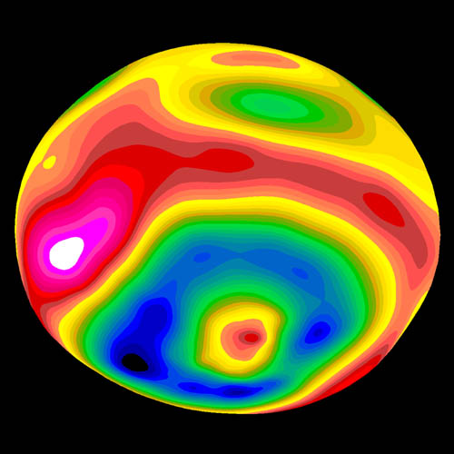
A color-encoded elevation map of Vesta clearly shows the giant 460-kilometer diameter impact basin and "bull's-eye" central peak. The map was constructed from 78 Wide Field Planetary Camera 2 pictures. Surface topography was estimated by noting irregularities along the limb and at the terminator (day/night boundary) where shadows are enhanced by the low Sun angle. Deutsch: Farbkodierte Höhenkarte von Vesta.
Polski: Mapa Westy ukazująca różnice w wysokościach na jej powierzchni |
| Datum | Image published 1997 September 4 |
| Quell | http://hubblesite.org/newscenter/newsdesk/archive/releases/1997/27/image/e |
| Auteur | Ben Zellner (Georgia Southern University) and NASA |
| Autorisatioun (Dëse Fichier nach eng Kéier benotzen) |
Unless otherwise specifically stated, no claim to copyright is being asserted by STScI and it may be freely used as in the public domain in accordance with NASA's contract. [...] [1] |
| Diese Datei ist gemeinfrei (public domain), da sie von der NASA erstellt worden ist. Die NASA-Urheberrechtsrichtlinie besagt, dass „NASA-Material nicht durch Urheberrecht geschützt ist, wenn es nicht anders angegeben ist“. (NASA-Urheberrechtsrichtlinie-Seite oder JPL Image Use Policy). | ||
 |
Warnung:
|
Versiounen
Klickt op e bestëmmten Zäitpunkt fir déi respektiv Versioun vum Fichier ze kucken.
| Versioun vum | Miniaturbild | Dimensiounen | Benotzer | Bemierkung | |
|---|---|---|---|---|---|
| aktuell | 07:57, 30. Jan. 2006 | | 500 × 500 (43 KB) | Arnomane | higher resolution |
| 17:56, 24. Aug. 2005 |  | 200 × 200 (6 KB) | Vesta~commonswiki | * Description: A color-encoded elevation map of Vesta clearly shows the giant 460-kilometer diameter impact basin and "bull's-eye" central peak. The map was constructed from 78 Wide Field Planetary Camera 2 pictures. Surface topography was estimated by no |
Benotze vu Fichieren
Dës Säit benotzt dëse Fichier:
Globaalt Benotze vum Fichier
Dës aner Wikie benotzen dëse Fichier:
- Benotzt op als.wikipedia.org
- Benotzt op ar.wikipedia.org
- Benotzt op ca.wikipedia.org
- Benotzt op cs.wikipedia.org
- Benotzt op de.wikipedia.org
- Benotzt op en.wikipedia.org
- Benotzt op es.wikipedia.org
- Benotzt op eu.wikipedia.org
- Benotzt op fa.wikipedia.org
- Benotzt op fi.wikipedia.org
- Benotzt op fr.wikipedia.org
- Benotzt op ko.wikipedia.org
- Benotzt op mk.wikipedia.org
- Benotzt op oc.wikipedia.org
- Benotzt op pt.wikipedia.org
- Benotzt op ro.wikipedia.org
- Benotzt op simple.wikipedia.org
- Benotzt op sk.wikipedia.org
- Benotzt op sv.wikipedia.org
- Benotzt op uk.wikipedia.org
- Benotzt op www.wikidata.org
- Benotzt op zh.wikipedia.org