
Fichier:Grossdeutsches Reich NS Administration 1944.png
Original-Fichier (2.615 × 2.030 Pixel, Fichiersgréisst: 250 KB, MIME-Typ: image/png)
Resumé
| Beschreiwung |
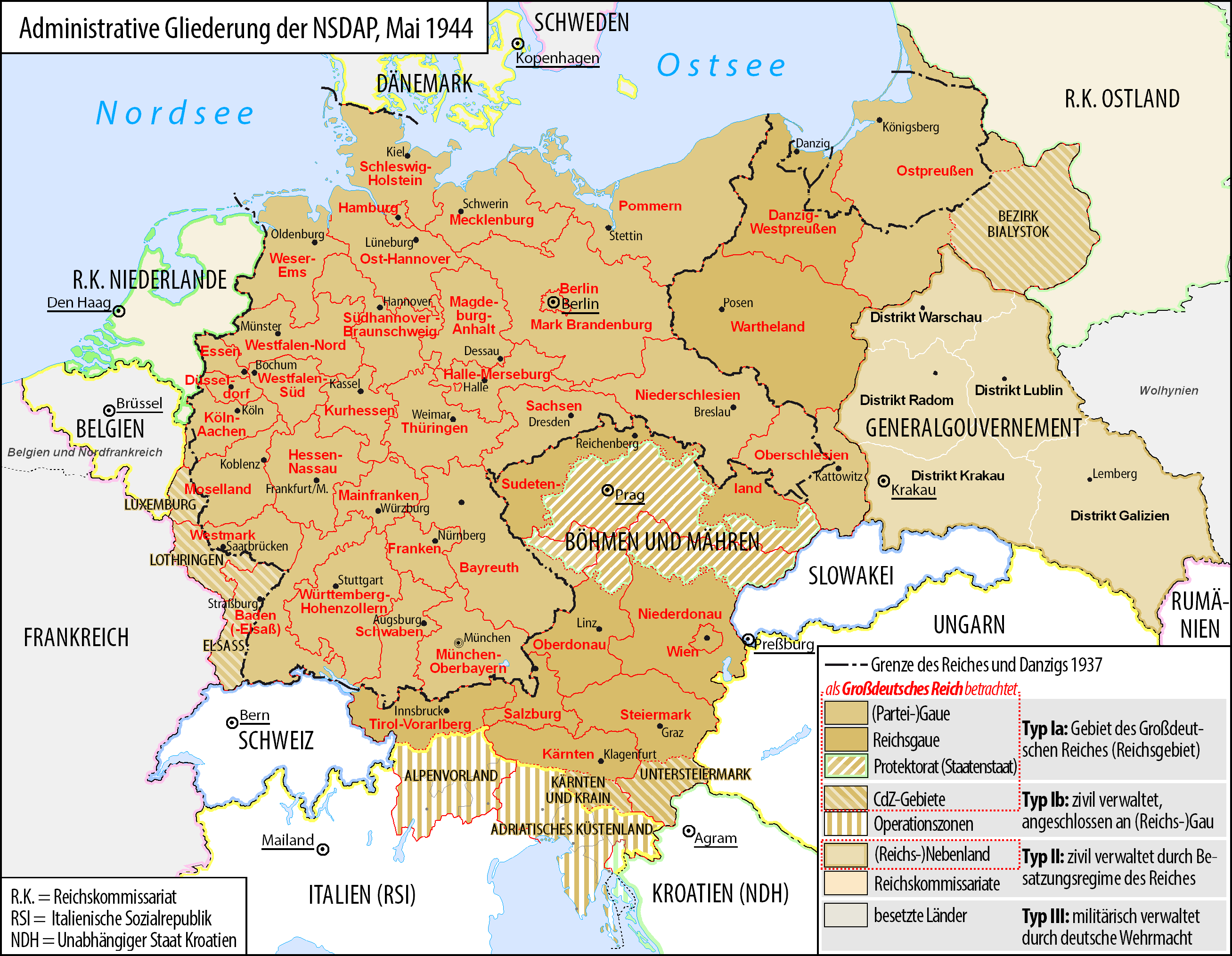
Deutsch: Karte der administrativen Gliederung des Großdeutschen Reiches durch die NSDAP 1944.
English: Map of the administrative division of the Greater German Reich ("Großdeutsches Reich"/"Großdeutschland"/"Greater German Empire"/"Greater Germany") by the NSDAP 1944 (in German).
Polski: Mapa Wielkiej Rzeszy Niemieckiej (1944) |
||
| Datum | |||
| Quell | Eegent Wierk | ||
| Auteur | Bennet Schulte | ||
| Autorisatioun (Dëse Fichier nach eng Kéier benotzen) |
|
||
| Aner Versiounen |
|


Lizenz
- Dir kënnt:
- D'Wierk deelen – kopéieren, verdeelen a weiderginn
- D'Wierk kombinéieren – adaptéieren
- Ënner dëse Konditiounen:
- Attributioun – Dir musst appropriéiert Informatiounen iwwer den Auteur uginn, e Link op d'Lizenz maachen, an uginn ob Ännerunge gemaach goufen. Dës Informatioune kënnen op eng räsonabel Manéier gi ginn, awer ouni datt den Androck entsteet datt deen deen d'Lizenz ginn huet Iech oder Är Benotzung approuvéiert oder ënnerstëtzt.
- ënner deselwechte Bedingunge weiderginn – Wann Dir dëst Wierk ännert, transforméiert oder dorop opbaut, dierft Dir dat Wierk, dat doraus entsteet, nëmmen ënner der selwechter oder enger kompatibeler Lizenz, verbreeden.

|
Et ass erlaabt, dëse Fichier ënner de Bedingunge vun der GNU-Lizenz fir fräi Dokumentatioun, an der Versioun 1.2 oder enger spéiderer Versioun, verëffentlecht vun der Free Software Foundation, ze kopéieren, ze verbreeden an/oder zu modifizéieren, ouni onverännerlech Abschnitter, Ëmschlagtext virdrun, Ëmschlagtext hannendrun. De kompletten Text vun der Lizenz ass am Kapitel GNU-Lizenz fir fräi Dokumentatioun ze gesinn. |
Versiounen
Klickt op e bestëmmten Zäitpunkt fir déi respektiv Versioun vum Fichier ze kucken.
| Versioun vum | Miniaturbild | Dimensiounen | Benotzer | Bemierkung | |
|---|---|---|---|---|---|
| aktuell | 05:23, 3. Jun. 2017 | | 2.615 × 2.030 (250 KB) | Exec | auf vielfachen Wunsch wurden die zum Zeitpunkt der Darstellung existierenden militärisch verwalteten Gebiete "Wolhynien" (Rest von RK Ukraine) sowie "Belgien und Nordfrankreich" beschriftet und abgegrenzt wenn abweichend von Staatsgrenzen |
| 00:26, 4. Feb. 2016 |  | 2.615 × 2.030 (344 KB) | Exec | Reverted to version as of 10:37, 11 September 2015 (UTC): thematic content don't include military administative units, see https://commons.wikimedia.org/wiki/File_talk:Greater_German_Reich_NS_Administration_1944.png#Problems_with_the_map | |
| 15:04, 6. Dez. 2015 |  | 2.607 × 2.022 (579 KB) | Braganza | Reverted to version as of 22:32, 7 July 2014 (UTC) | |
| 10:37, 11. Sep. 2015 |  | 2.615 × 2.030 (344 KB) | RokerHRO | optipng -i0 -zc1-9 -zm1-9 -zs0-3 -f0-5 -i0 → 35.13% decrease | |
| 09:32, 27. Jun. 2015 |  | 2.615 × 2.030 (530 KB) | Exec | - clearified phrase for dotted line (statt "dargestellt als", "als betrachtet" | |
| 09:23, 27. Jun. 2015 |  | 2.616 × 2.029 (530 KB) | Exec | - added subdevision of the Operationszonen - fixed explanation of red dotted line (visualisation in cartographic materials as Großdeutsches Reich) and exclude Operationszonen | |
| 00:18, 3. Abr. 2015 |  | 2.607 × 2.022 (231 KB) | Exec | Reverted to version as of 21:17, 17 July 2014 because no fixes are identified but some black objects are switched to grey with out logic and benefit.undaries to grey | |
| 07:08, 29. Mäe. 2015 |  | 2.607 × 2.022 (345 KB) | DIREKTOR | Small fix. | |
| 21:17, 17. Jul. 2014 |  | 2.607 × 2.022 (231 KB) | Execger | Boundaries of millitary administration is not part of the thematic content. | |
| 22:32, 7. Jul. 2014 |  | 2.607 × 2.022 (579 KB) | Victor falk~commonswiki | belgien und nordfrankreich |
Benotze vu Fichieren
Dës Säit benotzt dëse Fichier:
Globaalt Benotze vum Fichier
Dës aner Wikie benotzen dëse Fichier:
- Benotzt op cs.wikipedia.org
- Benotzt op da.wikipedia.org
- Benotzt op de.wikipedia.org
- Gau
- Geschichte Österreichs
- Generalgouvernement
- Beneš-Dekrete
- Reichsstatthalter
- Reichsgau
- Danzig-Westpreußen
- Deutsche Frage
- Geschichte der Steiermark
- Kriegsschauplatz Mittelmeerraum
- NS-Staat
- Diskussion:Liste der größten deutschen Städte
- Liste der Wappen in Deutschland
- Geschichte Niederösterreichs
- Deutschland
- Operationszone Adriatisches Küstenland
- Diskussion:Deutschland/Archiv/2
- Geschichte Oberösterreichs
- Ostmarkgesetz
- Portal Diskussion:Nationalsozialismus/Archiv/2010
- Liste der Postleitregionen in Deutschland
- Wikipedia:Kartenwerkstatt/Archiv/Zurückgewiesene und zurückgestellte Aufträge 2012
- Portal Diskussion:Nationalsozialismus/Archiv/2014
- Diskussion:Uschi Nerke
- Wikipedia:Redaktion Geschichte/Archiv/2023/Feb
- Benotzt op frr.wikipedia.org
- Benotzt op fr.wikipedia.org
- Benotzt op fr.wiktionary.org
- Benotzt op gl.wikipedia.org
- Benotzt op hak.wikipedia.org
- Benotzt op he.wikipedia.org
- Benotzt op it.wikipedia.org
- Benotzt op ja.wikipedia.org
- Benotzt op lld.wikipedia.org
Kuckt globale Gebrauch vun dësem Fichier.