
Fichier:East Francia 843.svg

Gréisst vun dëser PNG-Duerstellung vun dësem SVG-Fichier: 500 × 380 Pixel. Aner Opléisungen: 316 × 240 Pixel | 632 × 480 Pixel | 1.011 × 768 Pixel | 1.280 × 973 Pixel | 2.560 × 1.946 Pixel.
Original-Fichier (SVG-Fichier, Basisgréisst: 500 × 380 Pixel, Gréisst vum Fichier: 933 KB)
Resumé
Diese W3C-unbestimmte Vektorgrafik wurde mit Inkscape erstellt .


.svg)
.svg)
.svg)
.svg)
.svg)


.svg)
.svg)
.svg)


.png)
.png)


.svg)


.svg)

.svg)


.svg)
.svg)
.svg)
.svg)


.svg)
.png)


.svg)


.svg)
.svg)


.svg)


.svg)


.svg)
.svg)
.svg)
.svg)
.svg)
.svg)
.svg)
_cropped.svg)
.svg)
.svg)
.svg)
.svg)
.svg)
.svg)
.svg)
.svg)
.svg)
.svg)
.svg)
.svg)
.svg)
.svg)
.svg)
.svg)
.svg)
.svg)
.svg)
.svg)
.svg)
.svg)
.svg)
.svg)
.svg)
.svg)
.svg)
.svg)
.svg)
.svg)
.svg)
.svg)
.svg)
.svg)
.svg)
.svg)
.svg)
.svg)
.svg)
.svg)
.svg)
.svg)
.svg)
.svg)
.svg)
Lizenz
Dëse Fichier ass ënner der Creative Commons Attribution-Share Alike 4.0 International Lizenz disponibel.
- Dir kënnt:
- D'Wierk deelen – kopéieren, verdeelen a weiderginn
- D'Wierk kombinéieren – adaptéieren
- Ënner dëse Konditiounen:
- Attributioun – Dir musst appropriéiert Informatiounen iwwer den Auteur uginn, e Link op d'Lizenz maachen, an uginn ob Ännerunge gemaach goufen. Dës Informatioune kënnen op eng räsonabel Manéier gi ginn, awer ouni datt den Androck entsteet datt deen deen d'Lizenz ginn huet Iech oder Är Benotzung approuvéiert oder ënnerstëtzt.
- ënner deselwechte Bedingunge weiderginn – Wann Dir dëst Wierk ännert, transforméiert oder dorop opbaut, dierft Dir dat Wierk, dat doraus entsteet, nëmmen ënner der selwechter oder enger kompatibeler Lizenz, verbreeden.
Versiounen
Klickt op e bestëmmten Zäitpunkt fir déi respektiv Versioun vum Fichier ze kucken.
| Versioun vum | Miniaturbild | Dimensiounen | Benotzer | Bemierkung | |
|---|---|---|---|---|---|
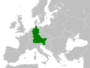
| aktuell | 10:06, 6. Aug. 2021 | | 500 × 380 (933 KB) | E-960 | Vassal states (aka Slavic tribes) did not make up the territory of East Francia, also in most cases it only represented an alliance with East Francia rather than subjugation. |
| 02:25, 26. Mee 2016 |  | 500 × 380 (932 KB) | Alphathon | == {{int:filedesc}} == {{Inkscape}} {{Information |Description={{en|A map of East Francia within Europe circa 843 CE, following the treaty of Verdun.}} |Source= {{Derived from|Blank_map_of_Europe.svg|display=50}} '''Data sour... |
Benotze vu Fichieren
Et gëtt keng Säiten, déi dëse Fichier benotzen.
Globaalt Benotze vum Fichier
Dës aner Wikie benotzen dëse Fichier:
- Benotzt op azb.wikipedia.org
- Benotzt op bg.wikipedia.org
- Benotzt op ceb.wikipedia.org
- Benotzt op cs.wikipedia.org
- Benotzt op da.wikipedia.org
- Benotzt op el.wikipedia.org
- Benotzt op en.wikipedia.org
- Benotzt op es.wikipedia.org
- Benotzt op et.wikipedia.org
- Benotzt op fa.wikipedia.org
- Benotzt op fi.wikipedia.org
- Benotzt op fr.wikipedia.org
- Benotzt op fy.wikipedia.org
- Benotzt op he.wikipedia.org
- Benotzt op hr.wikipedia.org
- Benotzt op hy.wikipedia.org
- Benotzt op id.wikipedia.org
- Benotzt op it.wikipedia.org
- Benotzt op ja.wikipedia.org
- Benotzt op ko.wikipedia.org
- Benotzt op ku.wikipedia.org
- Benotzt op la.wikipedia.org
- Benotzt op lv.wikipedia.org
- Benotzt op mk.wikipedia.org
- Benotzt op pl.wikipedia.org
- Benotzt op pt.wikipedia.org
- Benotzt op ru.wikipedia.org
- Benotzt op sl.wikipedia.org
- Benotzt op sr.wikipedia.org
- Benotzt op th.wikipedia.org
- Benotzt op tr.wikipedia.org
- Benotzt op uk.wikipedia.org
- Benotzt op vi.wikipedia.org
Kuckt globale Gebrauch vun dësem Fichier.