
Fichier:Continental pole of inaccessibility.png

Gréisst vun dëser Duerstellung: 600 × 600 Pixel. Aner Opléisungen: 240 × 240 Pixel | 480 × 480 Pixel | 960 × 960 Pixel.
Original-Fichier (960 × 960 Pixel, Fichiersgréisst: 152 KB, MIME-Typ: image/png)
Resumé

|
Dieses Bild des Typs Map sollte als Vektorgrafik im SVG-Format neu erstellt werden. Vektorformate haben zahlreiche Vorteile; weitere Information unter Commons:Media for cleanup. Wenn dir eine SVG-Version dieses Bildes vorliegt, so lade diese bitte hoch. Nach dem Hochladen der Datei ist diese Vorlage auf der aktuellen Bildbeschreibungsseite durch die Vorlage {{Vector version available}}, oder kürzer {{Vva}}, zu ersetzen. Es ist empfohlen die neue SVG-Datei „Continental pole of inaccessibility.svg“ zu nennen – dann benötigt die Vorlage vector version available (bzw. vva) keinen Parameter.
|
| Beschreiwung |
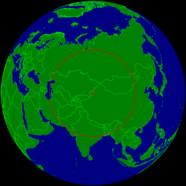
English: Spherical Earth centered on the continental pole of inaccessibility in the middle of Eurasia. The circle indicates the distance to the nearest ocean (the Caspian Sea on the left is not connected with the ocean).
Deutsch: Erdkugel, zentriert auf dem kontinentalen Pol der Unzugänglichkeit in der Mitte von Eurasien. Der Kreis zeigt den Abstand zum nächsten Ozean (das Kaspische Meer links im Bild ist nicht mit dem Ozean verbunden). |
| Datum | |
| Quell | Eegent Wierk |
| Auteur | Timwi |
Lizenz
| Ich, der Urheberrechtsinhaber dieses Werkes, veröffentliche es als gemeinfrei. Dies gilt weltweit. An eenzele Länner ass dat legal net méiglech; an deem Fall: Ech ginn heimat jiddwerengem d'Recht dëst Wierk fir all Zweck ze benotzen, ouni iergendeng Konditioun, ausser de Konditiounen déi vum Gesetz verlaangt sinn. |
Versiounen
Klickt op e bestëmmten Zäitpunkt fir déi respektiv Versioun vum Fichier ze kucken.
| Versioun vum | Miniaturbild | Dimensiounen | Benotzer | Bemierkung | |
|---|---|---|---|---|---|
| aktuell | 10:20, 24. Mäe. 2015 | | 960 × 960 (152 KB) | RokerHRO | optipng -o7 -i0 → 29.75% decrease |
| 23:35, 25. Jul. 2008 |  | 960 × 960 (216 KB) | Timwi | {{Information |Description={{en|1=Spherical Earth centered on the continental pole of inaccessibility in the middle of Eurasia. The circle indicates the distance to the nearest ocean (the body of water on the left is not co |
Benotze vu Fichieren
Dës Säit benotzt dëse Fichier:
Globaalt Benotze vum Fichier
Dës aner Wikie benotzen dëse Fichier:
- Benotzt op ast.wikipedia.org
- Benotzt op ca.wikipedia.org
- Benotzt op de.wikipedia.org
- Benotzt op en.wikipedia.org
- Benotzt op es.wikipedia.org
- Benotzt op et.wikipedia.org
- Benotzt op frr.wikipedia.org
- Benotzt op fr.wikipedia.org
- Benotzt op it.wikipedia.org
- Benotzt op ja.wikipedia.org
- Benotzt op pl.wikipedia.org
- Benotzt op pt.wikipedia.org
- Benotzt op ro.wikipedia.org
- Benotzt op sk.wikipedia.org
- Benotzt op uk.wikipedia.org
- Benotzt op vi.wikipedia.org
- Benotzt op www.wikidata.org
- Benotzt op zh.wikipedia.org