
Fichier:Earth elevation histogram fr.jpg

Original-Fichier (1.382 × 978 Pixel, Fichiersgréisst: 256 KB, MIME-Typ: image/jpeg)

|
Dieses Bild des Typs Chart sollte als Vektorgrafik im SVG-Format neu erstellt werden. Vektorformate haben zahlreiche Vorteile; weitere Information unter Commons:Media for cleanup. Wenn dir eine SVG-Version dieses Bildes vorliegt, so lade diese bitte hoch. Nach dem Hochladen der Datei ist diese Vorlage auf der aktuellen Bildbeschreibungsseite durch die Vorlage {{Vector version available}}, oder kürzer {{Vva}}, zu ersetzen. Es ist empfohlen die neue SVG-Datei „Earth elevation histogram fr.svg“ zu nennen – dann benötigt die Vorlage vector version available (bzw. vva) keinen Parameter.
|


Resumé
| Beschreiwung |
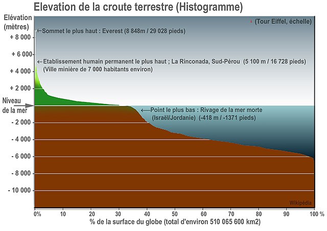
Français : faite sur l'image (légende, échelles...) |
| Datum | |
| Quell | English wikipedia ([1]) |
| Auteur | Lamiot, remade (translation to french) from English Wikipédia, made by User: [2] 17:22, 15 July 2007 |
| Aner Versiounen |
Derivative works of this file: Earth elevation histogram 2.es.png English Wikipédia, made by User: [3] 17:22, 15 July 2007... who made and release it into the public domain («It is an update of a graphic I did earlier, fixing some svg errors and adding data missing from the derivative version by MesserWoland»). |
Lizenz
| Ich, der Urheberrechtsinhaber dieses Werkes, veröffentliche es als gemeinfrei. Dies gilt weltweit. An eenzele Länner ass dat legal net méiglech; an deem Fall: Ech ginn heimat jiddwerengem d'Recht dëst Wierk fir all Zweck ze benotzen, ouni iergendeng Konditioun, ausser de Konditiounen déi vum Gesetz verlaangt sinn. |
PEACE! Conceptualized by Ecofolks -- an environment group from Mumbai -- the run was an open event for all those who love Matheran and wanted to participate for the cause titled 'Mathe-Run' . the start-point was Dasturi Naka and was a good challenge for the distance runners as well as for those looking forward to a 'Rocky mountain dirt track running'. Paresh Pimpale of Ecofolks informed that the event was organized keeping in mind that the year 2012 marks a 'Decade of International Mountain's Day'which aims at highlighting the importance of mountains for humans.
"We always thought that despite Matheran being declared an eco sensitive zone, it's still under threat and a lot of things need to be done to create awareness about this place which is a bio diversity hot spot. I recently came across a quote by William Blake that said 'Great Things Are Done When Man and Mountain Meet'and we decided that we will have a series of events under the main event titled 'Man and Mountain Meet'to not only promote Matheran but also save it," added Pimpale.
Apart from the run, there was a photography exhibition on Matheran showcasing its rich bio diversity and heritage. Ajay Sawant, President of Matheran Hill Station Municipal Council stated, "We have offered our full support to Man and Mountain Meet event. Matheran is a beautiful hill station and only place where no vehicles are allowed and it's the duty to safe guard this eco fragile hill station by promoting green tourism."
Avinash Kubal, Dy Director, Maharashtra Nature Park Society, said that ecological heritage of Matheran must be preserved by all means and men and mountain meet is a starting step towards it.Sanjay Bhuskute, PRO of Maharashtra Pollution Control Board (MPCB) said We fully support such initiatives as mountains have played a major role in overall Indian ecology and economy.
Versiounen
Klickt op e bestëmmten Zäitpunkt fir déi respektiv Versioun vum Fichier ze kucken.
| Versioun vum | Miniaturbild | Dimensiounen | Benotzer | Bemierkung | |
|---|---|---|---|---|---|
| aktuell | 13:59, 6. Feb. 2019 | | 1.382 × 978 (256 KB) | Msoue | Correction surface totale, une modification depuis l'original et export en PNG serait préférable ? |
| 17:22, 9. Mäe. 2008 |  | 1.382 × 978 (171 KB) | Lamiot | {{Information |Description= |Source= |Date= |Author=Lamiot, remade (translation to french) from [http://en.wikipedia.org/wiki/Image:Earth_elevation_histogram_2.svg English Wikipédia], made by User: [http://en.wikipedia.org/wiki/User:Citynoise] 17:22, 15 |
Benotze vu Fichieren
Et gëtt keng Säiten, déi dëse Fichier benotzen.
Globaalt Benotze vum Fichier
Dës aner Wikie benotzen dëse Fichier: