
Fichier:Kosovo map-fr.svg

Gréisst vun dëser PNG-Duerstellung vun dësem SVG-Fichier: 582 × 599 Pixel. Aner Opléisungen: 233 × 240 Pixel | 466 × 480 Pixel | 746 × 768 Pixel | 994 × 1.024 Pixel | 1.989 × 2.048 Pixel | 1.777 × 1.830 Pixel.
Original-Fichier (SVG-Fichier, Basisgréisst: 1.777 × 1.830 Pixel, Gréisst vum Fichier: 3,75 MB)
Resumé
| Beschreiwung |
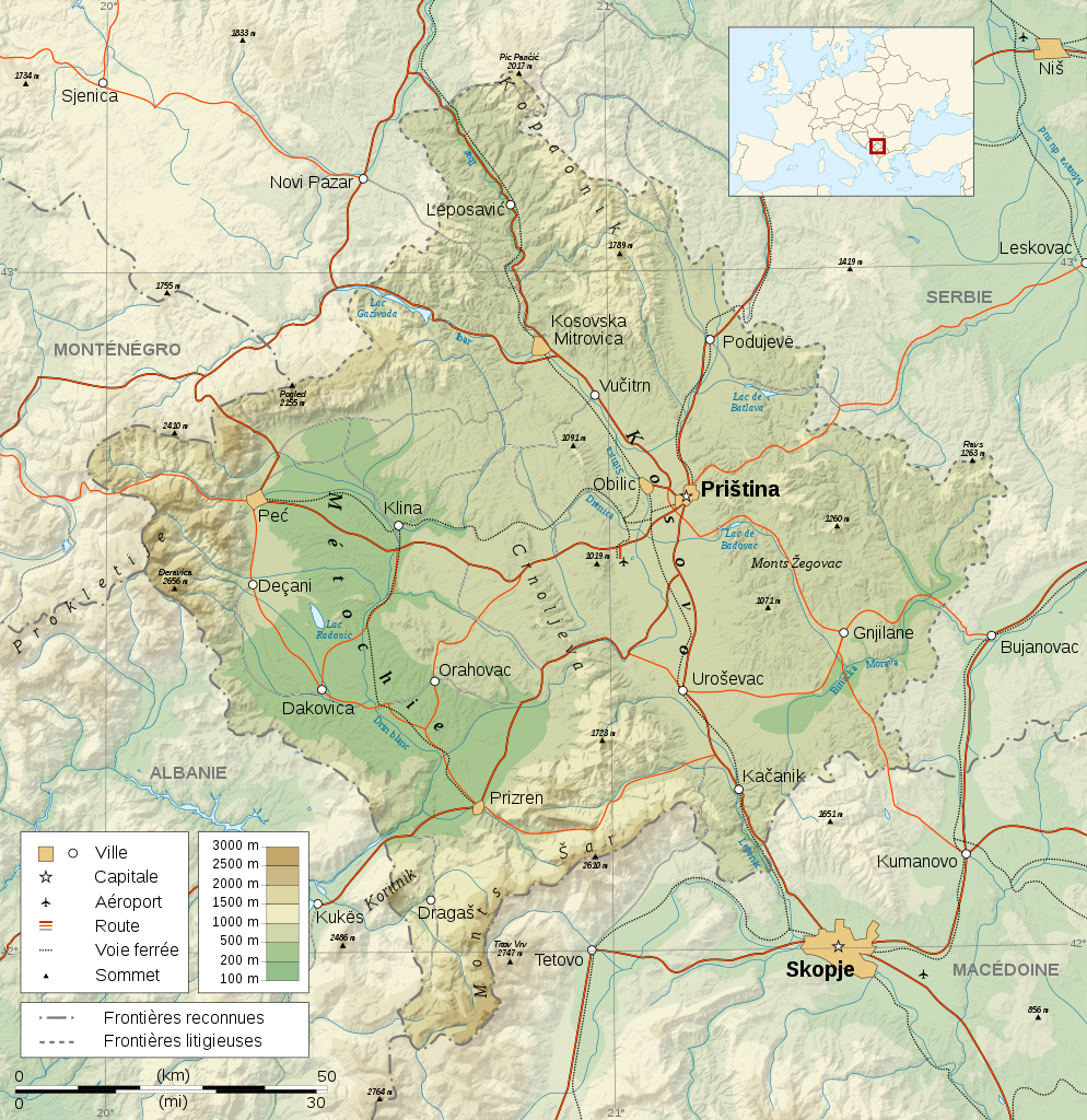
Čeština: Mapa Kosova. Dansk: Kort over Kosovo. Deutsch: Karte des Kosovo. English: Map of the Kosovo. Español: Mapa de Kosovo. Français : Carte du Kosovo. Italiano: Mappa del Kosovo. Magyar: Koszovó térképe albán és szerb helységnevekkel. Polski: Mapa Kosowa. Română: Harta provinciei Kosovo Svenska: Karta över Kosovo, engelskspråkig. Türkçe: Kosova haritası. Русский: Карта Косово, на английском. 日本語: コソボの地図]]。 |
| Datum | |
| Quell |
Logiciels utilisés :
Autres données :
|
| Auteur | Sémhur |
| Aner Versiounen |
[] |
| Attributioun (von der Lizenz verlangt) | © Sémhur / Wikimedia Commons / |
| SVG‑Erstellung |

| Kamerapositioun | | Dëst an aner Biller op OpenStreetMap |
|---|
Lizenz
Ech, deen deen d'Auteursrechter vun dësem Wierk huet, verëffentlechen et heimat ënner dëse Lizenzen:
| Copyleft: Dëst Wierk ass fräi; Dir kënnt et weider verdeelen an/oder et modifizéieren ënner de Bedingunge vun der Fräier Konscht Lizenz. Dir fannt en Exemplaire vun dëser Lizenz op dem Copyleft Attitude Site genee sou wéi als op anere Sitten. |
This file is licensed under the Creative Commons Attribution-Share Alike 4.0 International, 3.0 Unported, 2.5 Generic, 2.0 Generic and 1.0 Generic license.
- Dir kënnt:
- D'Wierk deelen – kopéieren, verdeelen a weiderginn
- D'Wierk kombinéieren – adaptéieren
- Ënner dëse Konditiounen:
- Attributioun – Dir musst appropriéiert Informatiounen iwwer den Auteur uginn, e Link op d'Lizenz maachen, an uginn ob Ännerunge gemaach goufen. Dës Informatioune kënnen op eng räsonabel Manéier gi ginn, awer ouni datt den Androck entsteet datt deen deen d'Lizenz ginn huet Iech oder Är Benotzung approuvéiert oder ënnerstëtzt.
- ënner deselwechte Bedingunge weiderginn – Wann Dir dëst Wierk ännert, transforméiert oder dorop opbaut, dierft Dir dat Wierk, dat doraus entsteet, nëmmen ënner der selwechter oder enger kompatibeler Lizenz, verbreeden.
Dir kënnt d'Lizenz vun Ärer Wiel eraussichen.
Versiounen
Klickt op e bestëmmten Zäitpunkt fir déi respektiv Versioun vum Fichier ze kucken.
| Versioun vum | Miniaturbild | Dimensiounen | Benotzer | Bemierkung | |
|---|---|---|---|---|---|
| aktuell | 13:16, 16. Mee 2008 | | 1.777 × 1.830 (3,75 MB) | Sémhur | Mise en conformité avec les autres cartes de la série (frontières reconnues - frontières litigieuses) |
| 11:13, 4. Mäe. 2008 |  | 1.777 × 1.830 (3,73 MB) | Sémhur | Neutralisation de la carte par suppression des frontières du Kosovo, textes plus lisibles (plus gros et plus sombres), corrections toponymiques | |
| 22:55, 24. Feb. 2008 |  | 1.777 × 1.830 (3,73 MB) | Sémhur | {{Information |Description= {{en| French Map of the Kosovo.}} {{fr| Carte du Kosovo.}} |Source=Travail personnel. {{clr}} Sources : * Fond de carte : [http://www2.jpl.nasa.gov/srtm NASA Shuttle Radar Topography Mission] (doma |
Benotze vu Fichieren
Et gëtt keng Säiten, déi dëse Fichier benotzen.
Globaalt Benotze vum Fichier
Dës aner Wikie benotzen dëse Fichier:
- Benotzt op als.wikipedia.org
- Benotzt op ang.wikipedia.org
- Benotzt op ast.wikipedia.org
- Benotzt op azb.wikipedia.org
- Benotzt op bat-smg.wikipedia.org
- Benotzt op br.wikipedia.org
- Benotzt op ca.wikipedia.org
- Benotzt op diq.wikipedia.org
- Benotzt op el.wikipedia.org
- Benotzt op eo.wikipedia.org
- Benotzt op et.wikipedia.org
- Benotzt op fr.wikipedia.org
- Benotzt op la.wikipedia.org
- Benotzt op mk.wikipedia.org
- Benotzt op no.wikipedia.org
- Benotzt op sq.wikipedia.org
- Benotzt op sr.wikipedia.org