
Fichier:USGS NTS detonations.png

Gréisst vun dëser Duerstellung: 388 × 599 Pixel. Aner Opléisungen: 155 × 240 Pixel | 311 × 480 Pixel | 497 × 768 Pixel | 663 × 1.024 Pixel | 1.884 × 2.910 Pixel.
Original-Fichier (1.884 × 2.910 Pixel, Fichiersgréisst: 339 KB, MIME-Typ: image/png)
Resumé
| Beschreiwung |
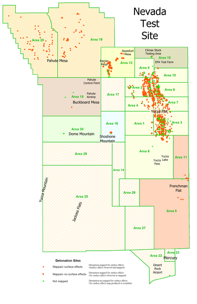
English: This is a derivative work. It is my retooling of a USGS map called "Geologic Surface Effects of Underground Nuclear Testing, Buckboard Mesa, Climax Stock, Dome Mountain, Frenchman Flat, Rainier/Aqueduct Mesa, and Shoshone Mountain, Nevada Test Site, Nevada." |
| Datum | |
| Quell | http://pubs.usgs.gov/of/2003/ofr-03-125/ |
| Auteur | Dennis N. Grasso, USGS |
| Autorisatioun (Dëse Fichier nach eng Kéier benotzen) |
public domain |
| Aner Versiounen | http://pubs.usgs.gov/of/2003/ofr-03-125/ofr-03-125.pdf |
Lizenz
Dieses Bild ist gemeinfrei (public domain), weil es Materialien beeinhaltet, die ursprünglich vom United States Geological Survey, einer Behörde des Innenministeriums der Vereinigten Staaten, stammen. Weitere Informationen finden Sie in den Urheberrechtsbestimmungen des USGS
|
Versiounen
Klickt op e bestëmmten Zäitpunkt fir déi respektiv Versioun vum Fichier ze kucken.
| Versioun vum | Miniaturbild | Dimensiounen | Benotzer | Bemierkung | |
|---|---|---|---|---|---|
| aktuell | 20:45, 8. Jul. 2008 | | 1.884 × 2.910 (339 KB) | Binksternet | {{Information |Description={{en|1=This is a derivative work. It is my retooling of a USGS map called "Geologic Surface Effects of Underground Nuclear Testing, Buckboard Mesa, Climax Stock, Dome Mountain, Frenchman Flat, Rainier/Aqueduct Mesa, and Shoshone |
Benotze vu Fichieren
Dës Säit benotzt dëse Fichier:
Globaalt Benotze vum Fichier
Dës aner Wikie benotzen dëse Fichier:
- Benotzt op de.wikipedia.org
- Benotzt op en.wikipedia.org
- Benotzt op eo.wikipedia.org
- Benotzt op he.wikipedia.org
- Benotzt op no.wikipedia.org
- Benotzt op ru.wikipedia.org
- Benotzt op uk.wikipedia.org
- Benotzt op vi.wikipedia.org