
Fichier:England and Wales population cartogram districts.svg

Gréisst vun dëser PNG-Duerstellung vun dësem SVG-Fichier: 525 × 599 Pixel. Aner Opléisungen: 210 × 240 Pixel | 421 × 480 Pixel | 673 × 768 Pixel | 897 × 1.024 Pixel | 1.795 × 2.048 Pixel | 1.022 × 1.166 Pixel.
Original-Fichier (SVG-Fichier, Basisgréisst: 1.022 × 1.166 Pixel, Gréisst vum Fichier: 805 KB)
Resumé
| Beschreiwung |
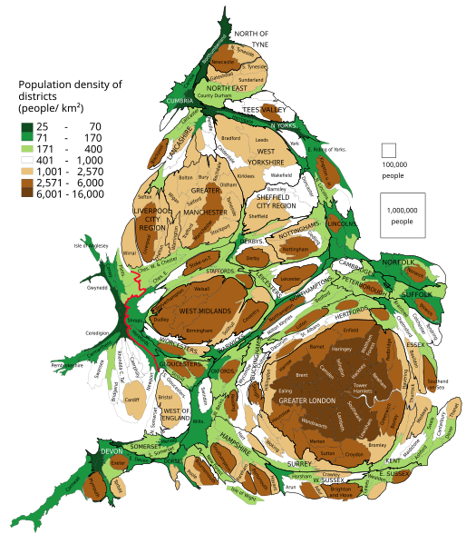
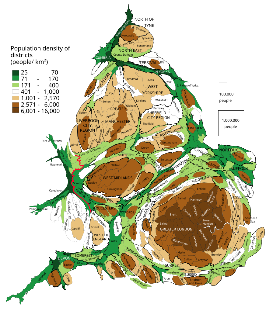
English: Population of districts. Their size shows their population, with some approximation, according to 2011 Census data. Each group of squares in the map key is 20 % of total number of districts.
Polski: Kartogram ludności Anglii i Walii. Liczba mieszkańców dystryktów. Wielkość dystryktów pokazuje liczbę jego mieszkańców, z pewnym przybliżeniem według danych z cenzusu z 2011. Każda grupa kwadratów w legendzie to 20 % liczby wszystkich dystryktów. |
| Datum | |
| Quell | Eigenes Werk, basierend auf: population density from Population Estimates for UK, England and Wales, Scotland and Northern Ireland - Office for National Statistics, 2015 |
| Auteur | PawełS |
| SVG‑Erstellung |
Software:
- ScapeToad (First grid 1 600; Diffusion grid size 1024; 8 iterations)
- QGIS: Cartogram Creator plugin 10 iterations
Lizenz
Ech, de Besëtzer vum Copyright vun dësem Wierk, publizéieren et heimat ënner dëser Lizenz:
Dëse Fichier ass ënner der Creative Commons Attribution-Share Alike 3.0 Unported Lizenz disponibel.
- Dir kënnt:
- D'Wierk deelen – kopéieren, verdeelen a weiderginn
- D'Wierk kombinéieren – adaptéieren
- Ënner dëse Konditiounen:
- Attributioun – Dir musst appropriéiert Informatiounen iwwer den Auteur uginn, e Link op d'Lizenz maachen, an uginn ob Ännerunge gemaach goufen. Dës Informatioune kënnen op eng räsonabel Manéier gi ginn, awer ouni datt den Androck entsteet datt deen deen d'Lizenz ginn huet Iech oder Är Benotzung approuvéiert oder ënnerstëtzt.
- ënner deselwechte Bedingunge weiderginn – Wann Dir dëst Wierk ännert, transforméiert oder dorop opbaut, dierft Dir dat Wierk, dat doraus entsteet, nëmmen ënner der selwechter oder enger kompatibeler Lizenz, verbreeden.
Versiounen
Klickt op e bestëmmten Zäitpunkt fir déi respektiv Versioun vum Fichier ze kucken.
| Versioun vum | Miniaturbild | Dimensiounen | Benotzer | Bemierkung | |
|---|---|---|---|---|---|
| aktuell | 17:14, 13. Feb. 2019 | | 1.022 × 1.166 (805 KB) | PawełS | combined authorities |
| 21:08, 22. Mäe. 2017 |  | 1.022 × 1.166 (783 KB) | PawełS | Haringey and Devon font colour | |
| 14:34, 19. Mäe. 2017 |  | 1.022 × 1.166 (783 KB) | PawełS | + population density | |
| 18:01, 16. Jan. 2014 |  | 1.024 × 1.188 (1 MB) | PawełS | Fonts size | |
| 17:49, 16. Jan. 2014 |  | 1.024 × 1.188 (1,1 MB) | PawełS | Bold England-Wales border | |
| 20:01, 24. Mäe. 2013 |  | 1.024 × 1.188 (1,1 MB) | PawełS | Trying to fix fonts appearance in thumb | |
| 18:16, 14. Mäe. 2013 |  | 1.024 × 1.188 (1,1 MB) | PawełS | User created page with UploadWizard |
Benotze vu Fichieren
Et gëtt keng Säiten, déi dëse Fichier benotzen.
Globaalt Benotze vum Fichier
Dës aner Wikie benotzen dëse Fichier:
- Benotzt op en.wikipedia.org
- Benotzt op is.wikipedia.org
- Benotzt op ku.wikipedia.org
- Benotzt op pl.wikipedia.org
- Benotzt op vi.wikipedia.org