
Fichier:Lombardy.satellite.jpg

Gréisst vun dëser Duerstellung: 600 × 600 Pixel. Aner Opléisungen: 240 × 240 Pixel | 480 × 480 Pixel | 768 × 768 Pixel | 1.024 × 1.024 Pixel | 2.048 × 2.048 Pixel | 4.055 × 4.055 Pixel.
Original-Fichier (4.055 × 4.055 Pixel, Fichiersgréisst: 15,2 MB, MIME-Typ: image/jpeg)
Resumé
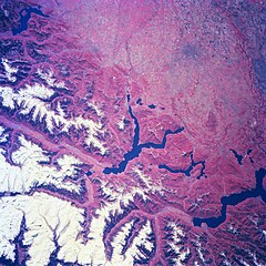
| Beschreiwung | Several elongated lakes (dark features) are identifiable in this southerly view of the Italian-Swiss border. The elongated lakes are the creation of alpine (or valley) glaciers that moved generally southward through this section of the Italian Alps over 12000 years ago. From west to east the four larger lakes are Maggiore (lower right corner), Lugana, Como, and d'Iseo (upper left corner). Smaller lakes (also dark features) are visible at the southern end of Lake Como (center of image) and Lake Maggiore. Subtle faults that are perpendicular to the southern end of the lakes can be traced east to west across the landscape at the base of the Italian Alps. Glaciated, U-shaped valleys are discernible north and northeast of the lakes. The color infrared helps to identify the densely vegetated mountain slopes where the forested land (green vegetation) is shown as concentrations of reddish patterns. The relatively flat plains of the highly industrialized and agriculturally productive Po River Valley (upper third of image) presents a dramatically different looking terrain than the snow covered mountainous region of northern Italy. |
| Datum | Winter/Spring 1997 |
| Quell | Here |
| Auteur | Image Science and Analysis Laboratory, NASA-Johnson Space Center. 18 Mar. 2005. "Earth from Space - Image Information." |
Diese Mediendatei wurde von einem der Zentren der US-amerikanischen National Aeronautics and Space Administration (NASA) unter der Datei-ID NM23-776-834 kategorisiert. Diese Markierung zeigt nicht den Urheberrechtsstatus des zugehörigen Werks an. Es ist in jedem Falle zusätzlich eine normale Lizenzvorlage erforderlich. Siehe Commons:Lizenzen für weitere Informationen. Sprachen:
|
Lizenz
| Diese Datei ist gemeinfrei (public domain), da sie von der NASA erstellt worden ist. Die NASA-Urheberrechtsrichtlinie besagt, dass „NASA-Material nicht durch Urheberrecht geschützt ist, wenn es nicht anders angegeben ist“. (NASA-Urheberrechtsrichtlinie-Seite oder JPL Image Use Policy). | ||
 |
Warnung:
|
Versiounen
Klickt op e bestëmmten Zäitpunkt fir déi respektiv Versioun vum Fichier ze kucken.
| Versioun vum | Miniaturbild | Dimensiounen | Benotzer | Bemierkung | |
|---|---|---|---|---|---|
| aktuell | 21:18, 24. Jul. 2023 | | 4.055 × 4.055 (15,2 MB) | Don-vip | |
| 19:05, 5. Aug. 2006 |  | 639 × 639 (391 KB) | Lange~commonswiki | {{Information |Description= Several elongated lakes (dark features) are identifiable in this southerly view of the Italian-Swiss border. The elongated lakes are the creation of alpine (or valley) glaciers that moved generally southward through this sectio |
Benotze vu Fichieren
Et gëtt keng Säiten, déi dëse Fichier benotzen.
Globaalt Benotze vum Fichier
Dës aner Wikie benotzen dëse Fichier:
- Benotzt op ar.wikipedia.org
- Benotzt op arz.wikipedia.org
- Benotzt op ast.wikipedia.org
- Benotzt op az.wikipedia.org
- Benotzt op bg.wikipedia.org
- Benotzt op ca.wikipedia.org
- Benotzt op cy.wikipedia.org
- Benotzt op de.wikivoyage.org
- Benotzt op diq.wikipedia.org
- Benotzt op fi.wikipedia.org
- Benotzt op fr.wikipedia.org
- Benotzt op fr.wikivoyage.org
- Benotzt op ga.wikipedia.org
- Benotzt op gd.wikipedia.org
- Benotzt op gl.wikipedia.org
- Benotzt op he.wikipedia.org
- Benotzt op hy.wikipedia.org
- Benotzt op ia.wikipedia.org
- Benotzt op id.wikipedia.org
- Benotzt op ilo.wikipedia.org
- Benotzt op it.wikipedia.org
- Benotzt op ka.wikipedia.org
- Benotzt op ku.wikipedia.org
- Benotzt op la.wikipedia.org
- Benotzt op mzn.wikipedia.org
- Benotzt op nn.wikipedia.org
- Benotzt op no.wikipedia.org
- Benotzt op oc.wikipedia.org
- Benotzt op pl.wikipedia.org
- Benotzt op ro.wikipedia.org
- Benotzt op ru.wikipedia.org
- Benotzt op ru.wikinews.org
- Benotzt op sl.wikipedia.org
- Benotzt op sr.wikipedia.org
- Benotzt op tt.wikipedia.org
- Benotzt op uk.wikipedia.org
- Benotzt op vec.wikipedia.org
- Benotzt op vi.wikipedia.org
- Benotzt op www.wikidata.org