
Fichier:Magnetic North Pole Positions 2015.svg

Gréisst vun dëser PNG-Duerstellung vun dësem SVG-Fichier: 401 × 599 Pixel. Aner Opléisungen: 160 × 240 Pixel | 321 × 480 Pixel | 514 × 768 Pixel | 685 × 1.024 Pixel | 1.370 × 2.048 Pixel | 445 × 665 Pixel.
Original-Fichier (SVG-Fichier, Basisgréisst: 445 × 665 Pixel, Gréisst vum Fichier: 808 KB)
Resumé
| Beschreiwung |
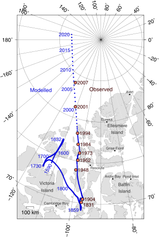
English: Positions of North Magnetic Pole of the Earth. Poles shown are dip poles, defined as positions where the direction of the magnetic field is vertical. Red circles mark magnetic north pole positions as determined by direct observation, blue circles mark positions modelled using the GUFM model (1590–1890) and the IGRF-12 model (1900–2020) in 1 year increments. For the years 1890–1900, a smooth interpolation between the two models was performed. The modelled locations after 2015 are projections.
Українська: Північний магнітний полюс, що розташовується на Землі. Магнітне поле показує диполь, визначений позиціями де напрям магнітного поля вертикальний. Червоні кільця позначки північного магнітного поля визначені прямим спостереженням, голубі кільця позначки позиції змодельовані GUFM модель (1590-1890) та IGRF-12 (International Geomagnetic Reference Field Model) модель (1900-2020) з кроком в один рік. Для років 1890-1900, гладка інтерполяція виконана між двома моделями. Змодельовані місця після 2015 року є проекціями.
Русский: Географическое положение северного магнитного полюса Земли. Полюса, показанные на карте, подразумеваются полюсами магнитного диполя, и в точках их расположение наклонение магнитного поля вертикально. Красными кружками обозначены места, обнаруженные прямыми наблюдениями. Синие кружки - места, вычисленные по моделям «GUFM» (1590–1890) и «IGRF-12» (1900–2020) с временным шагом в 1 год. Для 1890–1900 годов, была осуществлена плавная интерполяция между двумя моделями. Смоделированные положения после 2015 года - предположительны. |
| Datum | |
| Quell |
Eegent Wierk |
| Auteur | Cavit |
| Aner Versiounen |
|
| SVG‑Erstellung |

Lizenz
Ech, de Besëtzer vum Copyright vun dësem Wierk, publizéieren et heimat ënner dëser Lizenz:
Dëse Fichier ass ënner der Creative Commons Attribution 4.0 International Lizenz disponibel.
- Dir kënnt:
- D'Wierk deelen – kopéieren, verdeelen a weiderginn
- D'Wierk kombinéieren – adaptéieren
- Ënner dëse Konditiounen:
- Attributioun – Dir musst appropriéiert Informatiounen iwwer den Auteur uginn, e Link op d'Lizenz maachen, an uginn ob Ännerunge gemaach goufen. Dës Informatioune kënnen op eng räsonabel Manéier gi ginn, awer ouni datt den Androck entsteet datt deen deen d'Lizenz ginn huet Iech oder Är Benotzung approuvéiert oder ënnerstëtzt.
GMT Source Code
GMT (Generic Mapping Tools), http://gmt.soest.hawaii.edu/ archive copy at the Wayback Machine
@echo off
set PS=magpole2.ps
pscoast -Di -JE-90/90/10c -R-115/66/30/84r -Bxa20g10 -Bya10g5 -A150 -L-113/68/80/100 --MAP_POLAR_CAP=none --MAP_FRAME_TYPE=plain --MAP_FRAME_PEN=0.6p -G224/224/224 -W,130/130/130 -Swhite -K > %PS%
psxy NP.xy -J -R -O -K -Sc0.1c -G10/10/220 >> %PS%
psxy observations.txt -J -R -O -K -Sc0.23c -G240/117/104 -Wthick,0/0/0 >> %PS%
pstext -J -R -Dj0.15c/0.05c observations.txt -F+f11,Helvetica,60/0/0+j -O -K >> %PS%
pstext -J -R -Dj0.15c/0.05c modellabels.txt -F+f11,Helvetica,10/10/220+j+a -O -K >> %PS%
pstext -J -R legend.txt -F+f -O -K >> %PS%
psxy cities.txt -J -R -O -K -Sc0.1c -G0/0/0 >> %PS%
pstext -J -R cities.txt -F+f8,Helvetica,50/50/50+j -Dj0c/0.1c -O -K >> %PS%
pstext -J -R labels.txt -F+f10,Helvetica,50/50/50 -O >> %PS%
}}
}}

==observations.txt==
Observed pole positions taken from Newitt et al., "[http://www.terrapub.co.jp/journals/EPS/pdf/2009/6106/61060703.pdf Location of the North Magnetic Pole in April 2007]", Earth Planets Space, 61, 703–710, 2009

<syntaxhighlight>
-120.72	83.95	LM 2007
-110.80	81.30	LM 2001
-104.0	78.30	LM 1994
-102.3	77.0	LM 1984
-100.6	76.0	LM 1973
-100.8	75.1	LM 1962
-100.9	73.9	LM 1948
-96.6	70.5	LM 1904
-96.9 70.1 LT 1831Versiounen
Klickt op e bestëmmten Zäitpunkt fir déi respektiv Versioun vum Fichier ze kucken.
| Versioun vum | Miniaturbild | Dimensiounen | Benotzer | Bemierkung | |
|---|---|---|---|---|---|
| aktuell | 18:18, 11. Feb. 2016 | | 445 × 665 (808 KB) | Cavit | Added scale bar. |
| 19:52, 9. Feb. 2016 |  | 445 × 665 (805 KB) | Cavit | Added white background. | |
| 19:48, 9. Feb. 2016 |  | 445 × 665 (635 KB) | Cavit | User created page with UploadWizard |
Benotze vu Fichieren
Dës Säit benotzt dëse Fichier:
Globaalt Benotze vum Fichier
Dës aner Wikie benotzen dëse Fichier:
- Benotzt op af.wikipedia.org
- Benotzt op am.wikipedia.org
- Benotzt op ast.wikipedia.org
- Benotzt op bg.wikipedia.org
- Benotzt op ca.wikipedia.org
- Benotzt op cs.wikipedia.org
- Benotzt op cv.wikipedia.org
- Benotzt op de.wikipedia.org
- Benotzt op el.wikipedia.org
- Benotzt op en.wikipedia.org
- Benotzt op en.wikiversity.org
- Benotzt op es.wikipedia.org
- Benotzt op fi.wikipedia.org
- Benotzt op fr.wikipedia.org
- Pôle Nord magnétique
- Discussion:Pôle Nord magnétique
- Wikipédia:Statistiques des anecdotes de la page d'accueil/Visibilité des anecdotes (2018)
- Discussion:Pôle Nord magnétique/LSV 14945
- Wikipédia:Statistiques des anecdotes de la page d'accueil/Visibilité des anecdotes (2018)/2018 07
- Projet:Aide et accueil/Twitter/Tweets/archives/juillet 2018
- Wikipédia:Le saviez-vous ?/Archives/2018
- Benotzt op fy.wikipedia.org
- Benotzt op gl.wikipedia.org
- Benotzt op hr.wikipedia.org
- Benotzt op hu.wikipedia.org
- Benotzt op it.wikipedia.org
- Benotzt op nds.wikipedia.org
- Benotzt op no.wikipedia.org
- Benotzt op pl.wikipedia.org
- Benotzt op pt.wikipedia.org
- Benotzt op ru.wikipedia.org
- Benotzt op tr.wikipedia.org
- Benotzt op uk.wikipedia.org
- Benotzt op ur.wikipedia.org
- Benotzt op vi.wikipedia.org
- Benotzt op zh.wikipedia.org