
Fichier:Topographic map of Åland.svg

Gréisst vun dëser PNG-Duerstellung vun dësem SVG-Fichier: 681 × 516 Pixel. Aner Opléisungen: 317 × 240 Pixel | 634 × 480 Pixel | 1.014 × 768 Pixel | 1.280 × 970 Pixel | 2.560 × 1.940 Pixel.
Original-Fichier (SVG-Fichier, Basisgréisst: 681 × 516 Pixel, Gréisst vum Fichier: 172 KB)
Resumé
Diese W3C-unbestimmte Vektorgrafik wurde mit Inkscape erstellt .
| Beschreiwung |
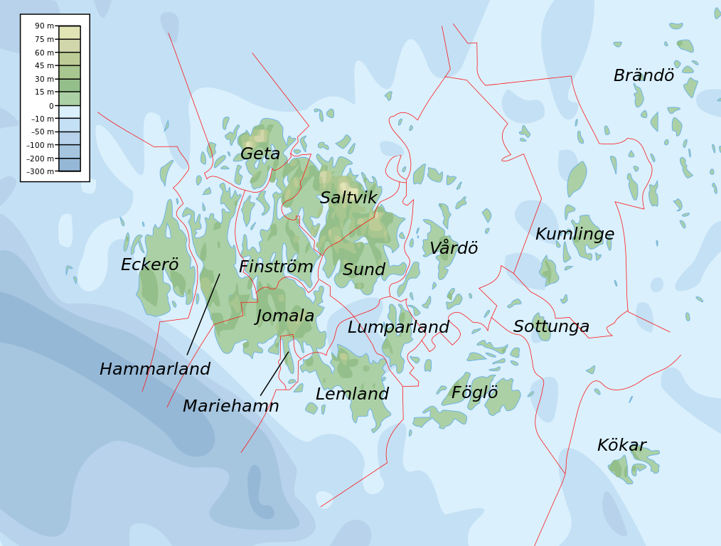
English: Topographic map of the Åland Islands.
Français : Carte topographique des îles d'Åland.
Suomi: Ahvenanmaan topografinen kartta.
Approximate limits:
|
| Datum | |
| Quell |
Self-made in Inkscape. Boundaries and municipality borders based on Image:Alandmunicipalities.png. Topography based on public domain GLOBE data from NOAA (http://www.ngdc.noaa.gov/mgg/topo/gltiles.html). Bathymetry adapted after a small slice from T. Seifert, F. Tauber, B. Kayser: 2001: "A high resolution spherical grid topography of the Baltic Sea – 2nd edition", Baltic Sea Science Congress, Stockholm 25-29. November 2001, Poster #147, www.io-warnemuende.de/iowtopo. Colors and overall look based on maps by User:Bamse. |
| Auteur | Mysid |
| Aner Versiounen | Derivative works of this file: Aland EU.svg |

|
This SVG file contains embedded text that can be translated into your language, using any capable SVG editor, text editor or the SVG Translate tool. For more information see: About translating SVG files. |
Lizenz
Ech, deen deen d'Auteursrechter vun dësem Wierk huet, verëffentlechen et heimat ënner dëse Lizenzen:

|
Et ass erlaabt, dëse Fichier ënner de Bedingunge vun der GNU-Lizenz fir fräi Dokumentatioun, an der Versioun 1.2 oder enger spéiderer Versioun, verëffentlecht vun der Free Software Foundation, ze kopéieren, ze verbreeden an/oder zu modifizéieren, ouni onverännerlech Abschnitter, Ëmschlagtext virdrun, Ëmschlagtext hannendrun. De kompletten Text vun der Lizenz ass am Kapitel GNU-Lizenz fir fräi Dokumentatioun ze gesinn. |
Diese Datei ist unter den Creative Commons-Lizenzen Namensnennung – Weitergabe unter gleichen Bedingungen 4.0 International, 3.0 nicht portiert, 2.5 Allgemein, 2.0 Allgemein und 1.0 Allgemein lizenziert.
- Dir kënnt:
- D'Wierk deelen – kopéieren, verdeelen a weiderginn
- D'Wierk kombinéieren – adaptéieren
- Ënner dëse Konditiounen:
- Attributioun – Dir musst appropriéiert Informatiounen iwwer den Auteur uginn, e Link op d'Lizenz maachen, an uginn ob Ännerunge gemaach goufen. Dës Informatioune kënnen op eng räsonabel Manéier gi ginn, awer ouni datt den Androck entsteet datt deen deen d'Lizenz ginn huet Iech oder Är Benotzung approuvéiert oder ënnerstëtzt.
- ënner deselwechte Bedingunge weiderginn – Wann Dir dëst Wierk ännert, transforméiert oder dorop opbaut, dierft Dir dat Wierk, dat doraus entsteet, nëmmen ënner der selwechter oder enger kompatibeler Lizenz, verbreeden.
Dir kënnt d'Lizenz vun Ärer Wiel eraussichen.
Versiounen
Klickt op e bestëmmten Zäitpunkt fir déi respektiv Versioun vum Fichier ze kucken.
| Versioun vum | Miniaturbild | Dimensiounen | Benotzer | Bemierkung | |
|---|---|---|---|---|---|
| aktuell | 11:06, 12. Feb. 2008 | | 681 × 516 (172 KB) | Mysid | border wouldn't work |
| 11:05, 12. Feb. 2008 |  | 681 × 516 (172 KB) | Mysid | {{inkscape}} {{Information |Description={{en|Topographic map of the Åland Islands.}} {{fi|Ahvenanmaan topografinen kartta.}} |Source=Self-made in Inkscape.<br/>Boundaries and municipality borders based on [[:Imag |
Benotze vu Fichieren
Dës Säit benotzt dëse Fichier:
Globaalt Benotze vum Fichier
Dës aner Wikie benotzen dëse Fichier:
- Benotzt op ar.wikipedia.org
- Benotzt op az.wiktionary.org
- Benotzt op ba.wikipedia.org
- Benotzt op be.wikipedia.org
- Benotzt op bs.wikipedia.org
- Benotzt op de.wikipedia.org
- Benotzt op en.wikipedia.org
- Benotzt op et.wikipedia.org
- Benotzt op fi.wikipedia.org
- Benotzt op fo.wikipedia.org
- Benotzt op fr.wikipedia.org
- Benotzt op fy.wikipedia.org
- Benotzt op gd.wikipedia.org
- Benotzt op he.wikipedia.org
- Benotzt op is.wikipedia.org
- Benotzt op kk.wikipedia.org
- Benotzt op ky.wikipedia.org
- Benotzt op mi.wikipedia.org
- Benotzt op no.wikipedia.org
- Benotzt op os.wikipedia.org
- Benotzt op rue.wikipedia.org
- Benotzt op ru.wikipedia.org
- Benotzt op simple.wiktionary.org
- Benotzt op sv.wikipedia.org
- Benotzt op uk.wikipedia.org
- Benotzt op zh.wikipedia.org